
The Bureau of Meteorology has released its monthly and seasonal climate outlooks for July to September 2017.
In the months ahead:
- Below average rainfall is likely in parts of the southeast and southwest of the country.
- Warmer-than-average days and nights are likely for much of Australia.
- Climate influences include higher-than-average pressure over southern Australia.
Climate outlook overview
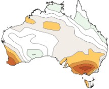
July to September rainfall is likely to be below average over parts of southeastern and southwestern Australia.
July to September daytime and night-time temperatures are likely to be warmer than average for most of Australia. Chances are highest in the southeast and southwest, where there is a greater than 80% chance of warmer than average days and nights.
This outlook is influenced by higher than average pressure over southern Australia during July to September (see the Climate Influences section for more detail).
Climate influences
The El Niño–Southern Oscillation (ENSO) remains neutral. All international climate models suggest ENSO is now likely to remain neutral for the remainder of 2017.
The Indian Ocean Dipole (IOD) remains neutral. Outlooks from the Bureau’s climate model suggest the IOD will remain neutral for at least the next three months. However, about half of the international climate models surveyed by the Bureau suggest a positive IOD remains possible, which typically brings drier weather to southern and central Australia.
While the Bureau’s climate model suggests the IOD and ENSO are likely to remain neutral, pressures are likely to remain high over the coming season with the sub-tropical ridge over Australia shifted southwards, and the Southern Annular Mode—or SAM—forecast to be positive at least for much of July. When SAM is positive, the global belt of high pressure in the southern hemisphere mid-latitudes shifts southwards, pushing cold fronts and moisture to the south of Australia.
In addition to the natural drivers such as the El Niño–Southern Oscillation and the IOD, Australian climate patterns are being influenced by the long-term increasing trend in global air and ocean temperatures.
Bureau climatologists continually monitor the climate for any significant developments, with information on El Niño/La Niña and IOD events available fortnightly via the ENSO Wrap-Up. For a summary of Pacific and Indian Ocean outlooks, please see the Climate Model Summary.
Drier July to September likely for parts of southern Australia
July to September rainfall is likely to be below average over southwest WA and southeast Australia.
A drier than average July is likely over southwest WA, and eastern NSW. Elsewhere, there are roughly equal chances of a wetter or drier month.
Higher than average mean sea level pressure is anticipated over southern Australia during July to September, which is likely to keep frontal systems and lows further south than usual, and reduce cloudiness over land.
Historical outlook accuracy for July to September is moderate over most of Australia, but low near the WA border and central SA. See map for more detail.
Warmer July to September days and nights for most of Australia
July to September daytime temperatures are likely to be warmer than average for most of Australia, except for southeast WA and western and central SA.
July to September nights are likely to be warmer than average for Australia, except over northwest and southeast SA and adjacent border areas.
While nights are likely to be warmer on average, very cold nights also remain likely during periods of high pressure and clear skies—watch local forecasts and warnings.
Chances of warmer days and nights are highest in the southwest, southeast and northeast, where there is a greater than 80% chance of warmer than average days and nights.
Historical maximum temperature accuracy for July to September is moderate to high over most of Australia. Minimum temperature accuracy is moderate over northern Australia and Tasmania, but low elsewhere.